


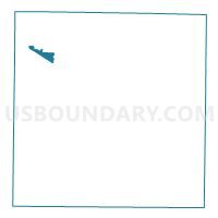
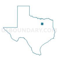
Voting District 4637, Dallas County, Texas
About
Outline

Summary
| Unique Area Identifier | 671929 |
| Name | Voting District 4637 |
| County | Dallas County |
| State | Texas |
| Area (square miles) | 2.91 |
| Land Area (square miles) | 2.75 |
| Water Area (square miles) | 0.17 |
| % of Land Area | 94.33 |
| % of Water Area | 5.67 |
| Latitude of the Internal Point | 32.88984900 |
| Longtitude of the Internal Point | -96.95007050 |
Maps

Graphs
Select a template below for downloading or customizing gragh for Voting District 4637, Dallas County, Texas


Neighbors
Neighoring Voting District (by Name) Neighboring Voting District on the Map
- Voting District 1101, Dallas County, TX
- Voting District 1511, Dallas County, TX
- Voting District 4621, Dallas County, TX
- Voting District 4628, Dallas County, TX
- Voting District 4634, Dallas County, TX
- Voting District 4636, Dallas County, TX
- Voting District 4640, Dallas County, TX
- Voting District 4644, Dallas County, TX
- Voting District 4650, Dallas County, TX
Top 10 Neighboring County Subdivision (by Population) Neighboring County Subdivision on the Map
- Northeast Dallas CCD, Dallas County, TX (1,455,973)
- Southwest Dallas CCD, Dallas County, TX (912,166)
Top 10 Neighboring Place (by Population) Neighboring Place on the Map
Top 10 Neighboring Unified School District (by Population) Neighboring Unified School District on the Map
- Dallas Independent School District, TX (1,020,846)
- Irving Independent School District, TX (170,884)
- Carrollton-Farmers Branch Independent School District, TX (167,408)
- Coppell Independent School District, TX (44,419)
Top 10 Neighboring State Legislative District Lower Chamber (by Population) Neighboring State Legislative District Lower Chamber on the Map
- State House District 105, TX (164,238)
- State House District 115, TX (140,868)
- State House District 103, TX (117,346)
Top 10 Neighboring State Legislative District Upper Chamber (by Population) Neighboring State Legislative District Upper Chamber on the Map
Top 10 Neighboring 111th Congressional District (by Population) Neighboring 111th Congressional District on the Map
Top 10 Neighboring Census Tract (by Population) Neighboring Census Tract on the Map
- Census Tract 143.12, Dallas County, TX (5,423)
- Census Tract 141.36, Dallas County, TX (5,418)
- Census Tract 141.24, Dallas County, TX (4,133)
- Census Tract 142.06, Dallas County, TX (3,877)
- Census Tract 141.38, Dallas County, TX (3,574)
- Census Tract 141.03, Dallas County, TX (3,015)
- Census Tract 141.37, Dallas County, TX (2,626)
- Census Tract 99, Dallas County, TX (2,537)
Top 10 Neighboring 5-Digit ZIP Code Tabulation Area (by Population) Neighboring 5-Digit ZIP Code Tabulation Area on the Map
- 75220, TX (41,891)
- 75063, TX (35,090)
- 75229, TX (31,571)
- 75234, TX (28,794)
- 75038, TX (27,802)
- 75039, TX (11,032)